Day 3: Descent into Cirque de Mafate and ascent to Îlet à Malheur (via Aurère).
Flip-Flops on the rocks
The map shows a very overgrown wall, the height lines are close together. It is hard to imagine that a path runs into the Cirque de Mafate here, but it does, the GR R2 is marked here. In less than 4 kilometres of trail, it descends 700 metres in altitude, and in the steepest part it is 300 metres in altitude in less than 700 metres of trail. In preparation, we were a little worried about this section.
We want to start early today to be able to catch up on some of the views we missed yesterday, in case the clouds roll in early again. We are lucky that our hosts are not late sleepers, there is actually breakfast from 6am and we have breakfast with the two French girls: fresh baguette, salted butter, jam, orange juice, good coffee, a selection of teas and fresh fruit, including the island’s wonderful mini bananas and small pineapples. It will be the last luxurious breakfast for a few days …
We start at 7:30 a.m. at 900 m altitude at Sentier de Bras Ste-Suzanne. Deux Bras is marked with a walking time of two hours. From our gîte we walk along the road for a short while, then our path branches off to the south and a little later we are high up on the slope. Soon we catch our first glimpse of the gorge. Deep below us lies the Rivière des Galets, which leads out of the Cirque de Mafate towards the sea. We will reach this river at the end of the descent and follow it – farting several times – against its direction of flow. In the direction of the river, we will see the port city of Le Port and the Indian Ocean. Right on the first metres, a 15 m high bamboo forms an archway for us.
 Rivière des Galets, © Markus Proske — NIKON Z 7, NIKKOR Z 24-70mm f/2.8 S, 24mm, 1/50s, Blende 11, ISO 400
 Blick entlang des Rivière des Galets nach Le Port, © Markus Proske — NIKON Z 7, NIKKOR Z 24-70mm f/2.8 S, 70mm, 1/1250s, Blende 2.8, ISO 64
 15m hoher Bambus
Despite the very steep gradient in sections, the trail is quite unproblematic. Sometimes the path is very narrow, sometimes more exposed. The slope drops very steeply towards the river. However, due to the dense vegetation, there is no bad feeling or fear of heights. The path itself is varied: earth, forest floor, gravel, rocks, high steps, slippery sections, narrow sections. There are belays at tricky parts of the trail, there are iron clamps, a ladder and some taut steel ropes. It is better to keep your concentration high here, even away from the secured sections!


, © Markus Proske — NIKON Z 7, NIKKOR Z 24-70mm f/2.8 S, 24mm, 1/50s, Blende 11, ISO 360")


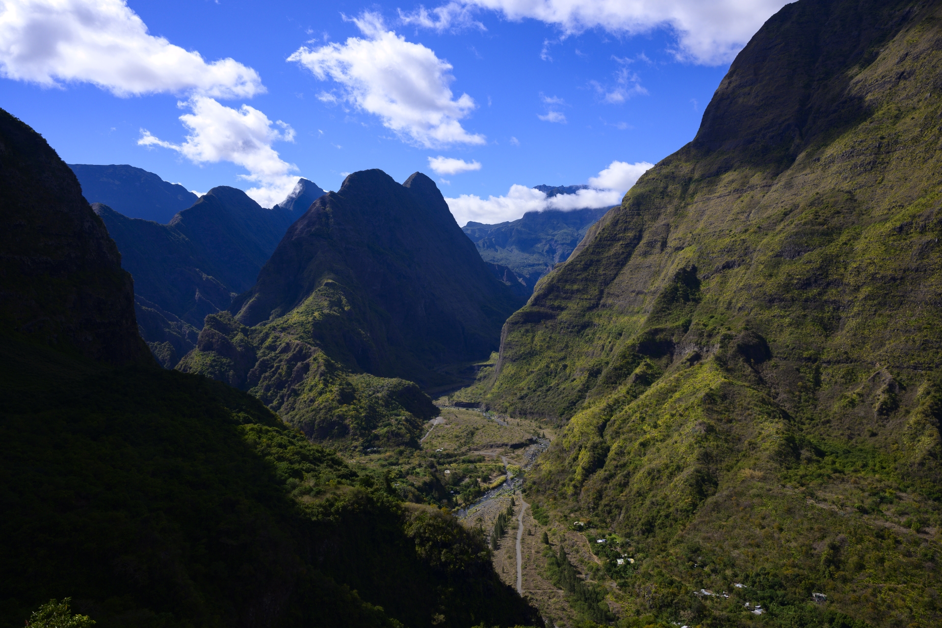
The following picture offers the chance to spatially classify our route. We are now much lower and looking south into the Cirque de Mafate. The river coming through the valley from the background of the picture is the Rivière des Galets. To the left of the river, a mountain range also runs from back to front, this is the Crête d’Aurère. The highest point of the Crête d’Aurère is the Piton Cabris, which we will go around today (and see again and again in the next few days), first walking backwards along the river and then climbing up to the Bord Bazar pass (from our point of view behind the Piton Cabris) and walking down again a little on the other side.
Now it gets exciting. The next mountain range to the left is the Crête de la Marianne. Between the two lies Aurère and our destination for the day, Îlet à Malheur, then a little further south. The mountain range on the far left? Behind it is the Plaine des Chicots and the southernmost point is Roche Écrite – it’s been less than 24 hours since we stood up there! Since then, we have virtually marched in a large arc to the left outside the picture to Dos d’Âne.
 Roche Écrite, Crête de la Marianne, Crête d’Aurère mit Piton Cabris, Rivière des Galets und im Hintergrund in den Wolken der Morne de Fourche, © Markus Proske — NIKON Z 7, NIKKOR Z 24-70mm f/2.8 S, 24mm, 1/50s, Blende 11, ISO 100
Bananas grow along the path! There is nothing to harvest yet, but we have long since earned a break and suitable sweets can be found in our backpacks.

At 11.15 a.m. we reach the low point of our tour – don’t worry, only in the geographical sense! 😉 250 m altitude, we will only be lower on the last day when we reach the sea in the south of the island. The place is called Deux Bras, the Bras de Ste-Suzanne flows into the Rivière des Galets here. Our walking time was just over 3 hours, in Dos d’Âne it was posted as 2 hours, but once again we are well above the time allowed by the locals on the descent.
Deux Bras is one of the main access points to Cirque de Mafate. The following times are written on the signposts: Grand Place École 2:45 h, Îlets de Lataniers 3 h and Aurère 3:10 h.
We first ford the Bras de Ste-Suzanne and then head backwards into the valley on a wide and fairly flat path.
We first ford the Bras de Ste-Suzanne and then head backwards into the valley on a wide and fairly flat path.


After a few river crossings – always over large stones and dry feet – we reach La Porte (290 m). Here you can continue along the river to Cayenne (1:40 h) or to the Îlets Îlet des Lataniers (2:25 h) or Îlet des Orangers (3:45 h). We want to go there on our tour, but before that we want to see more of Mafate and follow the R2: Aurère 2:35 h and Îlet à Malheur 3:15 h (Source Cabris 0:30 h).
Here we meet the French girls again and they tell us that they have called everywhere and have not been able to find accommodation for the night in Aurère, Îlet à Malheur, Îlet à Bourse or Grand Place and therefore cannot do the tour as planned and are going directly to Îlet des Orangers today. We wonder about the booking situation in the early season and are glad about our advance booking of all the huts. We wish them both all the best and continue our tour.
Here we meet the French girls again and they tell us that they have called everywhere and have not been able to find accommodation for the night in Aurère, Îlet à Malheur, Îlet à Bourse or Grand Place and therefore cannot do the tour as planned and are going directly to Îlet des Orangers today. We wonder about the booking situation in the early season and are glad about our advance booking of all the huts. We wish them both all the best and continue our tour.
We start the ascent punctually at noon. It goes steeply upwards again straight away. You notice that we are on a main access route here, the path is well developed and well secured. At the beginning of the path, in the first ascent out of the gorge, the stones of the steps are even fixed with concrete, later the steps consist of layered stones and wooden planks.
, © Markus Proske — NIKON Z 7, NIKKOR Z 24-70mm f/2.8 S, 24mm, 1/50s, Blende 8, ISO 500")
, © Markus Proske — NIKON Z 7, NIKKOR Z 24-70mm f/2.8 S, 39mm, 1/80s, Blende 8, ISO 280")
, © Markus Proske — NIKON Z 7, NIKKOR Z 24-70mm f/2.8 S, 33mm, 1/80s, Blende 8, ISO 140")
, © Markus Proske — NIKON Z 7, NIKKOR Z 24-70mm f/2.8 S, 34mm, 1/80s, Blende 8, ISO 720")
Half an hour later, at “Source Cabris”, we are already much higher at 420 metres. The view back is quite something: out of the valley, “left” towards the sea, the steep slope in the shade – here we crossed descending from Dos d’Âne!
 Piton Crete Dos d’Ane (Cap Noir) – da oben waren wir gestern, © Markus Proske — NIKON Z 7, NIKKOR Z 24-70mm f/2.8 S, 34mm, 1/80s, Blende 11, ISO 250
Time jump: two hours have passed since Source Cabris, we have taken three short breaks and are already really tired in the legs. It goes up in one tour. The path is often steep and above all it contains an extremely large number of steps. The individual step heights range from often 30-40 cm to sometimes 50-70 cm, the latter then have a small additional step for the toe. We are not the only ones who struggle up here, there is a couple on the way who overtake us again and again, but we then pass them again a few bends further on while “regenerating”. We walk slowly, but for longer. 🙂
Three times, locals come towards us. First two middle-aged women, chatting and walking briskly. And two young men, running and jumping. No, not trail runners. Locals with empty backpacks, running to do their shopping. Downhill at breakneck speed. With flip-flops!
FLIP-FLOPS!
We feel slightly fooled 😉 and immediately have a suspicion how the times on the signs come about: these are the best times of the locals! As if to confirm this, a young man with a full backpack and a bag slung over his shoulder comes uphill later and passes us briskly, breathing calmly. Oida!
For our international readers: Oida is an extremely versatile expression in the Austrian language and can be used in more ways than almost any other word – you can find a short, very amusing explanatory video at Youtube.]
The water supply on today’s route is once again not assured. We used a water source quite late in the ascent for refreshment, a small rivulet, with a bamboo cut in half lengthwise as a drinking source, the coordinates: 21°1’31.868″ S / 55°25’7.444″ E. You should not rely on this and take enough water with you!
In the following picture, we would like to show you another part of our route: the peak in the clouds is Piton des Calumets. Just ahead is a high plateau (about in the middle of the picture). There is Grand Place, where we will have a sandwich in the bar for lunch tomorrow!
The next picture is again a picture back and you can see how the path hugs the slope closely, overcoming large differences in altitude over a short distance. The vegetation is extremely varied. Bamboo is rare and confined to small areas, but it gives us a lot of pleasure with its lush dense green and the beautiful light atmosphere!
 Ein Blick zurück auf unseren Weg, der sich an den Hang schmiegt, © Markus Proske — NIKON Z 7, NIKKOR Z 24-70mm f/2.8 S, 24mm, 1/50s, Blende 11, ISO 200
 Bambus, © Markus Proske — NIKON Z 7, NIKKOR Z 24-70mm f/2.8 S, 24mm, 1/50s, Blende 11, ISO 1250
The picture above shows again the Crête d’Aurère with Piton Cabris – which looks different from every direction! Shortly after the photo we are at the Bord Bazar pass at 950 m altitude. It’s 3pm, according to the signpost at La Porte we should have been in Aurère for 25 minutes. This will not be a new best time :/
There is a lot of activity on the small pass, the couple from the ascent, another couple and a large family having a picnic. From here it’s 15 easy minutes to Aurère. There is also a direct route to Îlet à Malheur (“Îlet à Malheur direct”), which is marked 50 min if you want to skip Aurère.
There is a lot of activity on the small pass, the couple from the ascent, another couple and a large family having a picnic. From here it’s 15 easy minutes to Aurère. There is also a direct route to Îlet à Malheur (“Îlet à Malheur direct”), which is marked 50 min if you want to skip Aurère.
In Aurère, we pass small gardens and simple little houses. We look for the bar that is supposed to exist in Aurère, but it’s not exactly a hive of activity here. Apart from us, there is no one to be seen. The bar looks closed, but at least there is a table outside and you can open the garden gate. Inside we actually find a friendly lady and buy a cold beer – our first Dodo! Dodo? The beer has been brewed since the 1960s by the Brasseries de Bourbon brewery, the first beer was called Dodo Pils. In the 1970s, the beer was renamed “Bourbon”, but it has always remained a Dodo in the island’s linguistic usage – and is still used as such in advertising: “La dodo lé la”.
Historically, dodo refers to a bird, long extinct and native to Mauritius [Wikipedia]. Contemporary accounts and paintings tell of a type of “white dodo” on Reunion. The story is complex, today’s science assumes that it is about the – also extinct – Réunionibis. If you want to know more, you can start here: [Wikipedia].


After the leisurely break, we continue on, the last few minutes to Îlet à Malheur. Once again there are two paths to choose from, “facile” and “rapide”. We take the easy way, we don’t fancy the faster one with a presumably steeper descent. Soon we catch our first glimpse of the Îlet à Malheur. Unfortunately, once again there is a deep gorge between us and the island, the Bras Bémale canyon. But this time we are lucky, we don’t have to descend all the way down, a narrow bridge leads high above the canyon.


At 5 pm we reach Îlet à Malheur. We first pass our gîte by mistake. We have booked the gîte Îlet a Malheur, but there is another name on the sign. In any case, it is the gîte right next to the church. We get a nice 4-bed room with shower and toilet and already have a roommate, Laurie from Paris. She is travelling alone and takes our tour in the opposite direction. After a hot shower, we write our diary and read a bit, and at 7 pm we have dinner.


Dinner is in a long narrow room with an equally long massive table. There would be room for 25 – 30 guests, but apart from Laurie there is only one couple staying in the 4-person hut next to us. We wonder why the two French women didn’t get a place to stay this afternoon, there was nothing going on at all in Aurère and obviously not here either. The couple are from Burgundy and are travelling the world without compromise. They sold their house in Burgundy and now they travel as long as they can get by with the money, then they look for jobs back home. They eat the national dish: salad, rice, lentils and chicken. The chicken is prepared in large pieces with all parts of the chicken, which is typical for the region. Even the whole foot with claw. No, we didn’t dare to taste the foot and neither did the French people.
The conversation at the table was of course in French, the owner of the gîte does not know English. The two French girls kindly always translate short summaries of longer conversations for us, so we learn: that it was a dry winter and unusually cold for the time of year; that the path from Plaine de Chicots to Dos d’Âne was closed yesterday (oops, we went there yesterday after all!); that our host holds an annual festival that lasts a week and attracts 3,000 guests during that time, who then camp everywhere and drink vast quantities of dodos. 🙂
For dessert we have a banana cake and flavoured rum, this time with aniseed and orange. At 9 pm we all go to bed – it was a long day after all.
For dessert we have a banana cake and flavoured rum, this time with aniseed and orange. At 9 pm we all go to bed – it was a long day after all.
Finally, a panorama that I took the next morning from the “vantage point” (past the church and then do not follow the R2 but straight ahead).
You can see Piton Cabris again on the right. But the really exciting thing about this picture is the rock face in the background, which is over 2,000 m high in places. On a plateau of about 1,000 m – unfortunately not visible due to a rock face in front of it, near the tall tree in the middle of the picture – lies the Îlet des Orangers, where we will be the day after tomorrow! And on the left, where the band of clouds lies below the rock face, there is a ridge running down from the end of the clouds, with a hard dark shadow. The V-shaped incision: La Brèche, also the day after tomorrow, from here we will descend to Roche Plate!
You can see Piton Cabris again on the right. But the really exciting thing about this picture is the rock face in the background, which is over 2,000 m high in places. On a plateau of about 1,000 m – unfortunately not visible due to a rock face in front of it, near the tall tree in the middle of the picture – lies the Îlet des Orangers, where we will be the day after tomorrow! And on the left, where the band of clouds lies below the rock face, there is a ridge running down from the end of the clouds, with a hard dark shadow. The V-shaped incision: La Brèche, also the day after tomorrow, from here we will descend to Roche Plate!
 Ausblick auf den westlichen Rempart des Cirque de Mafate, © Markus Proske — NIKON Z 7, NIKKOR Z 24-70mm f/2.8 S, 28mm, 1/60s, Blende 8, ISO 160
To make it easier for you to follow, we have summarised and labelled the tour days in Cirque de Mafate on a map (Map data © OpenStreetMap contributors, Track Lustwandler.at):


This article has been semi-automatically translated as a service for foreign users. See details here.
Leave a Reply
Want to join the discussion?Feel free to contribute!