Sweden 2017: Prologue and route through the Kebnekaise Fjäll
The Fjäll in its autumn coat
Last year the Kungsleden was our late entry into the world of trekking – the tour was great and hardly back home we thought about what we could do next year. You can find last year’s almost three-week tour here. The choice for this year’s main holiday was Iceland – read here – but the desire to return to Sweden was strong and so we planned a little autumn tour in the mountains.
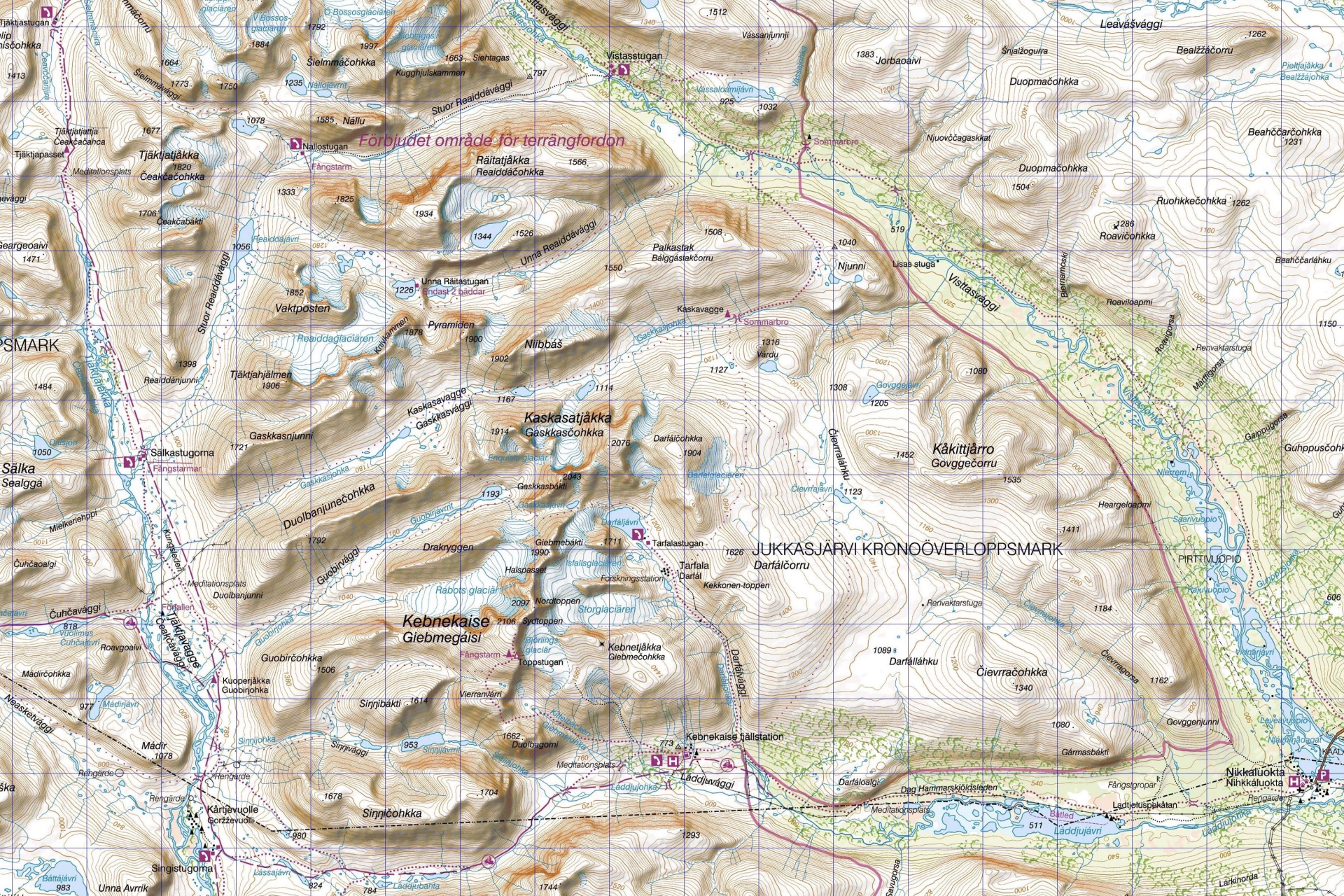
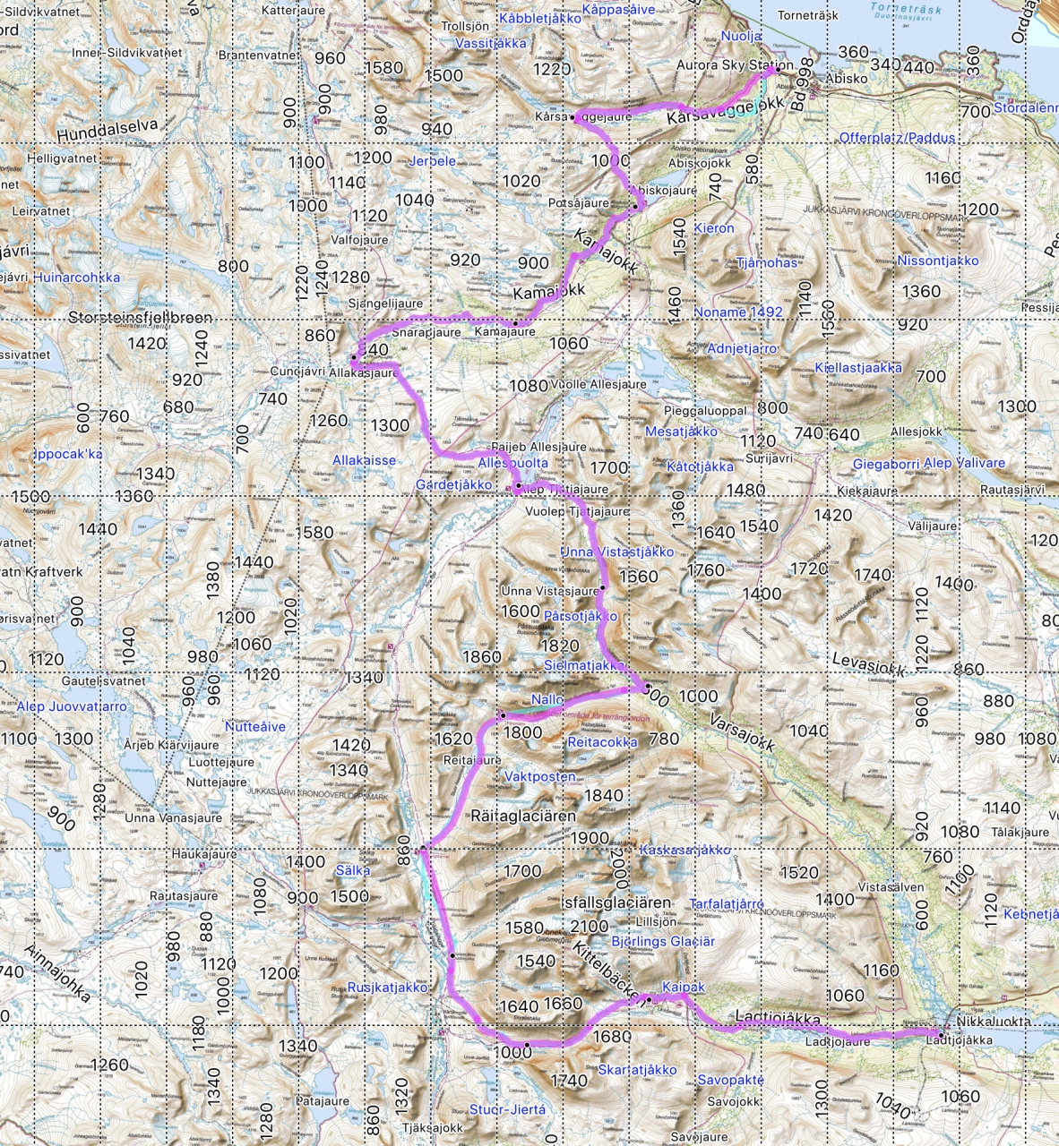
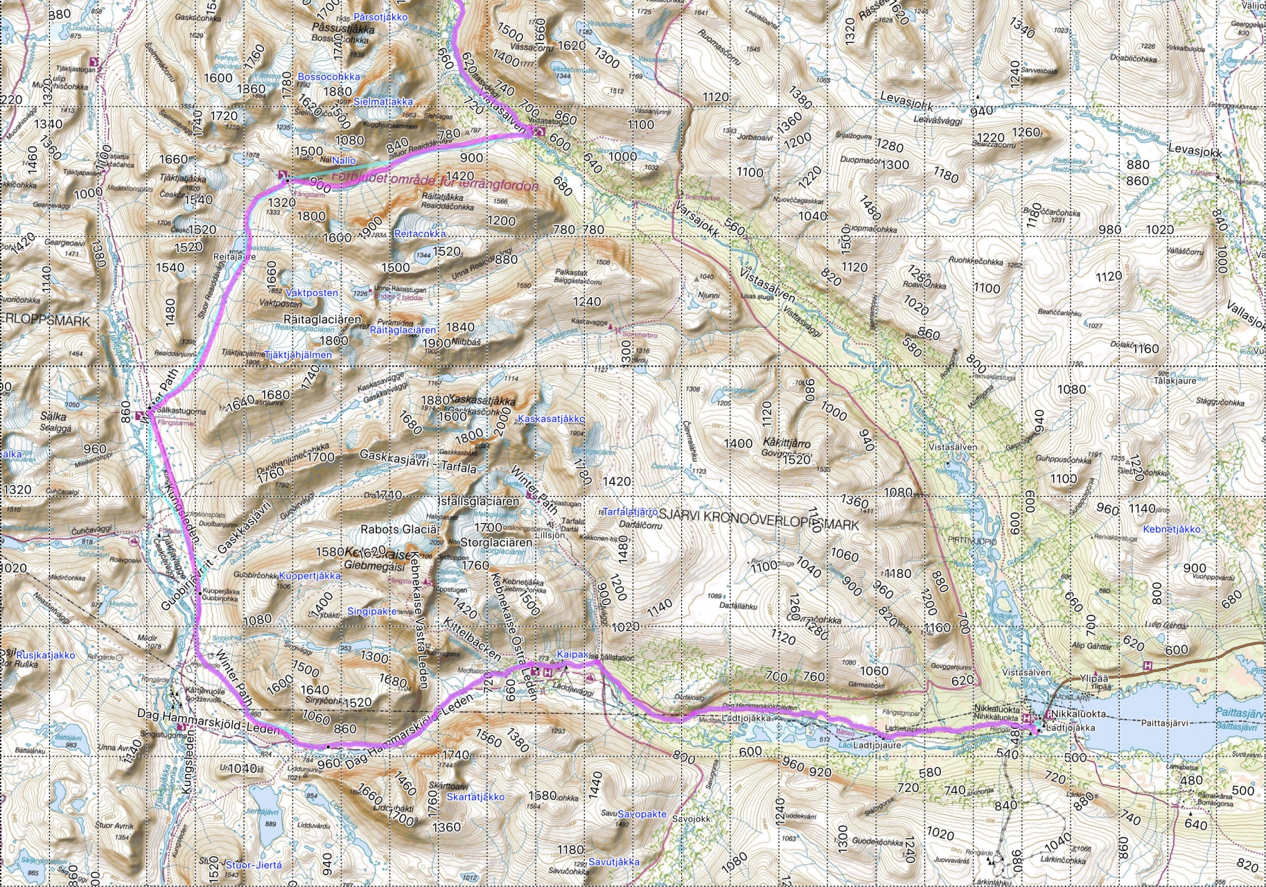
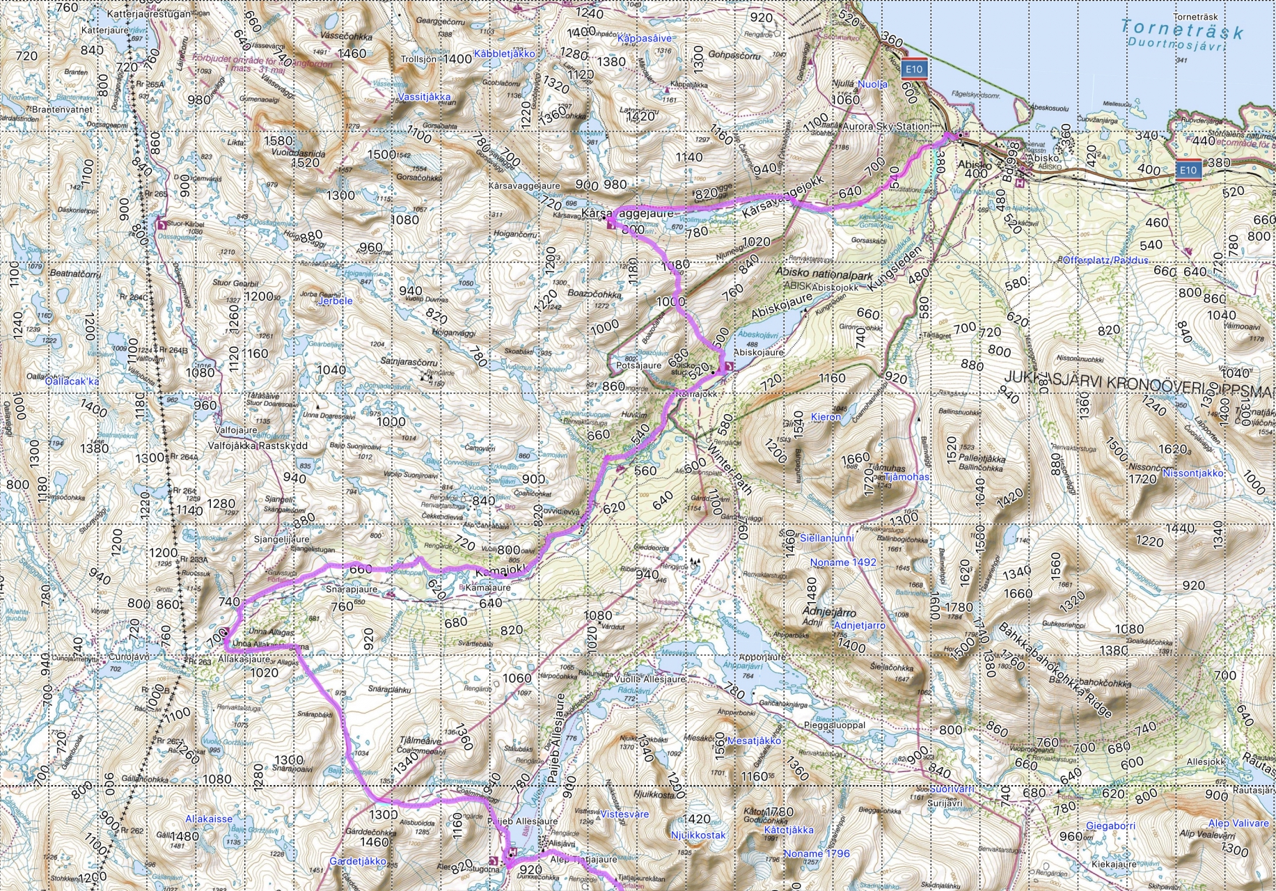
Start and finish point of the tour were quickly clear due to the good accessibility with start Nikkaluokta and finish in Abisko, also we wanted to leave the tent at home this time and decided to hike from cabin to cabin. However, we didn’t just want to take the route north, which we already knew in the opposite direction to Singi from last year. Instead, we laid the tour through enchanting and at this time of year quite lonely side valleys: Stuor Reaiddávággi, Visttasvággi, Čoalmmevággi, Abiskodalen between Unna Allakas and Abiskojaure and Kårsavagge. Of course we couldn’t go without “main valleys”, so we went long distances in Láddjuvággi and short distances in Tjäktjavagge and Alesvagge.
We went from Nikkaluokta via the Kebnekaise mountain station directly to Sälka and left the Kungsleden to go via Nallostugan and Vistasstugan to Alesjaure. The reward was a breathtaking mountain scenery in Nallo and – especially for us who had never seen Northern Lights before – a super Northern Lights night in Nallo! It was followed by a mystical Vistasvággi with wind, rain, clouds and fog. In Alesjaure we spent only one night and then went over the pass to Unna Allakas, where we spent three comfortable days in the dreamlike situated hut. From there we walked through the long valley to the crowded Abiskojaure and from there over the next pass to Kårsavagge and then followed the valley to Abisko.
The length of this tour was a moderate 140 km. On the following elevation profile you can see that jumping between the valleys is sometimes connected with proper climbs.

Divided into the individual days, this was our planning with rough elevation data for ascent/descent:
Nikkaluokta – Kebnekaise Fjällstation: 18 km, 200/20 HM
Kebnekaise Fjällstation – Sälkastugorna: 24 km, 400/200 HM
Sälkastugorna – Fjällstuga Nallo: 10 km, 220/160 HM
Fjällstuga Nallo – Fjällstuga Vistas: 10 km, 0/300 HM
Fjällstuga Vistas – Alesjaurestugorna (through the Vistasvággi): 17 km, 280/100 HM
Alesjaurestugorna – Unna Allakasstugorna: 15 km, 480/550 HM
Unna Allakasstugorna – Abiskojaurestugorna: 23 km, 20/220 HM
Abiskojaurestugorna – Kårsavaggestugan: 8km, 620/420 HM
Kårsavaggestugan – Abisko: 14km, 60/380 HM
(9 days, on average this is about 15,5km/day)
The size and the service offer of the huts differ, not all have a shop, the size of the shop varies and not everywhere there is a sauna. On the webpage of the STF you can find a List of Fjällstugas.
Our planned tour is covered by the map BD6 Abisko-Kebnekaise-Narvik.
Sweden has made underlying data of the maps publicly available (Lantmäteriet: http://www.lantmateriet.se/en/Maps-and-geographic-information/Maps/oppna-data). They can be viewed online at https://kso.etjanster.lantmateriet.se/?lang=en (switching from topo to fjällkartan). Based on these data you will find at http://bengt.nolang.se/kartor/fjallkartan excellent maps as high resolution JPGs and file formats for GPS devices. This is also the source for the screenshots on this page. I also build our daily maps this way. Simply copy screenshots of the corresponding section into a Word document and then print it in colour. The respective sheet of the day (folded in an A5 transparent cover) is quickly at hand and just as quickly stowed away again and you don’t have to treat it as carefully as the BD6. And in the evening it helps to start a fire! 🙂
Sweden has made underlying data of the maps publicly available (Lantmäteriet: http://www.lantmateriet.se/en/Maps-and-geographic-information/Maps/oppna-data). They can be viewed online at https://kso.etjanster.lantmateriet.se/?lang=en (switching from topo to fjällkartan). Based on these data you will find at http://bengt.nolang.se/kartor/fjallkartan excellent maps as high resolution JPGs and file formats for GPS devices. This is also the source for the screenshots on this page. I also build our daily maps this way. Simply copy screenshots of the corresponding section into a Word document and then print it in colour. The respective sheet of the day (folded in an A5 transparent cover) is quickly at hand and just as quickly stowed away again and you don’t have to treat it as carefully as the BD6. And in the evening it helps to start a fire! 🙂
Finally, the overall view of the route – larger and divided into three sections.

Leave a Reply
Want to join the discussion?Feel free to contribute!